Showing posts with label 1980's. Show all posts

Friday, July 28, 2023

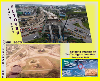
New Flyover over the former Roundabout One/Traffic Lights Junction


The Roundabout One in the 1980's have faced many transformation,  an indication of the rapid development of Bintulu town since its first boom days.
In 2014 the Roundabout One was turned into a Traffic Lights Junction.
Today, the site is witnessing a major transformation as a flyover is under construction above the traffic light junction.
To have a good history of roundabouts in Bintulu, please check my other blog by following this link....>>>https://bintulub4now.blogspot.com/search/label/Roundabouts

Monday, April 27, 2015

Wildlife Park of Bintulu in 1989

View of the Wildlife Park ( Taman Hidupan Liar) seen in 1989.
Works on the construction of the Wildlife Park or Taman Hidupan Liar in Malay started in 1989 and the park was officially opened to the general public on the 2nd of August,1991.
Picture shows my family members and their cousin, with our car driven right to the top of the hill where later the wordings  "Taman Hidupan Liar" were planted using cover plants approximately where  the car is parked.
View of the park  taken on 9th of March,2015. 
Today, the park is re-named as "Taman Tumbina".
 It was the first and only park of its kind in Sarawak when it was opened in 1991.  Today, the park is called "Taman Tumbina" but when it was first started and opened it was known as Taman Hidupan Liar or Wildlife Park.  It was one of my pet projects while in the Bintulu Development Authority (BDA).  This project brought me places to Singapore and West Malaysia to see similar projects and learn from them.  In the park (as shown in the layout plan below) there were many botanical as well as zoological attractions.  One of the big attractions was the flamingo pond.  Follow this link to know more in-depth story of my role in bringing the flamingoes to Bintulu  here .  In the top picture, the Bintulu coastline is seen in the background.  It is evident that that were no condominiums or high-rise buildings in Bintulu in the 1980's along its coasts.  The condominiums were a thing of the 1990's in Bintulu. 

" Taman Hidupan Liar " or Wildlife Park as seen in the early 1990's

Monday, March 2, 2015

Angsana trees along Kidurong Highway in 1982

View of Kidurong highway in 1982, looking towards Bintulu town.
The location is approximately near the present Indoor Stadium which is located at the left of the picture , after the steep slopes at the foreground.
The Angsana trees (Pterocarpus indicus) are planted from stumps.

View of Kidurong highway taken on 21 February, 2015.
Note the large size of the Angsana trees at left.  The central medium is planted with Tabebuia rosea/alba trees which are planted much later.
New cutting dated 15.8.1981
The Sarawak Tribune
'Angsana' trees or botanically known as Pterocarpus indicus was the main roadside tree species planted in the early 1980's when the Bintulu Development Authority (BDA) started with the landscaping of Bintulu town and the new township at Kidurong.  The Kidurong highway which started from the old Bintulu town center (Mile 0) ran for about 12 kilometers to reach the new Kidurong township.  On both sides of the dual-carriageway were planted Angsana trees.  Today, those trees planted more than 30 years ago have reached full maturity and still remain strong and sturdy.  They helped improved the micro-climate along the highway, protect road users from the sun and glare.  The greatest impact is in the creation of a green garden city look.  In 1982, BDA officially appointed Mr. A.G. Alphonso and Mr. Cheang Kok Choy ( shown at the inset) as landscaping and horticultural consultants to help advise BDA on the creation of Bintulu into a 'garden city'.  Below is the content of the news cutting as indicated in the inset : -
The Sarawak Tribune, August 15, 1981.
Landscaping specialists on visit.
Kuching, Fri. -  Two beautification and landscaping specialists, Mr. George Alphonso and Mr Cheang Kok Choy of Penang arrived here yesterday for a five day visit at the invitation of the Bintulu Development Authority.  Mr. George Alphonso told the Tribune that the Bintulu Development Authorty was taking the correct step of viewing seriously the beautification and landscaping of the booming town of Bintulu.  He also suggested that the State should keep a standard nursery for various plants and trees, particularly the instant trees for planting along the sides of roads.  Mr. George Alphonso is the former Director of the Singapore Botanical Garden while his associate, Mr. Cheang Kok Choy, is a former Director of the Penang Botanical Garden.  Mr Cheang is currently involved with the Shah Alam landscape project.  While in Bintulu, the experts will conduct a feasibility study on the beautification and landscaping of Bintulu.   The visitors were feted to dinner at a local restaurant last night by Encik Sulong Matjeraie, General Manager of the Bintulu Development Authority. (see picture) - Mohd. Jaya Tan.
Monday, February 2, 2015

Bintulu's first public housing undertaken by BDA using IBS system.

The first low- cost housing project in Bintulu using the industrialised building system (IBS) called Emy Prefab system.
The project was jointly funded by a Federal government loan and BDA internal funds for the benefit of people in Bintulu with a total household income of RM 750 per month and below.  The ceiling price of the houses (especially the double-storey units)  was capped at RM 35,000 per unit  and to be settled  over a 23 years repayment period at 4% interest by successful applicants.
Colour photo taken on 15 May,1984 shows the housing site next to the Kidurong highway.

View of RPR Kidurong (Phase 1) taken on 2 February,2015
Note: Houses with olive green roofing are Single-storey and red roofing are Double-storey houses.
View of RPR Kidurong (Rancangan Perumahan Rakyat) -  a public housing project undertaken by BDA, starting in 1983 with Phase One, consisting of 508 units with a mix of double-storey and single-storey terrace housing.
Colour photo shows construction progress of construction dated 15 May,1984.

Single -storey houses with olive green roofing
Taken : 2 February,2015
 During the first economic boom (1979 -1983) thousands of people from all over Sarawak sought employment in booming Bintulu.  One of the migrant workers requirements was housing especially those who decided to settle for good in Bintulu.  The Bintulu Development Authority (BDA) was at the fore-front of implementing change in Bintulu.  One of its early project was a low-cost housing  situated at the new satellite township of Kidurong.  The site was carefully chosen in order to enable the owners of the houses to commute easily to their places of work especially at the new Light and Heavy Kidurong Industrial estates around the Bintulu Port vicinity.   The project was also to help solve the problem of illegal squatters at Bintulu town who needed alternative housing once they were to be removed from the slum areas in the center of Bintulu town.  In late 1981 BDA's request for Federal funding was approved by the Federal Minisstry of Housing with the initial allocation of 15 million Malaysian Ringgit loan to be repaid over 25 years with a grace period of 2 years and 23 years repayment annuity, at o% interest.  The loan enabled BDA to build 508 units of low-cost houses for the low income group of people from various ethnic groups like the Chinese, Malay and Melanau, Ibans and other native groups.  The ceiling price of the most expensive units i.e. the Double-storey houses was pegged at RM 35,00 per unit.  The loan was disbursed gradually starting in 1982.  On 13 December 1983, The Chief Minister of Sarawak Datuk Patinggi Taib Mahmud laid the foundation stone for the project, targeted to be completed in 1985. Since the successful implementation of this Phase One project, BDA continued to undertake more low-cost housing projects in the same locality.  This RPR Housing project finally was enlarged to four phases, done over a time span of more than three decades.  The RPR Kidurong is unique in that it is the first public housing project served with a central sewerage system in Sarawak.
Double-storey houses with red roofing, RPR Kidurong (Phase 1) - which was completed in 1985.
Note: Over time the owners undertook extensions to the original building especially those with corner lots.
The strength, durability and quality of using EMY Prefab system is shown in the picture.  Despite using the prefah or industrialised building system, the houses remain firm and has a market value today(2015) at around RM 100,000 for a double-storey unit.
Photo taken by digital camera on 2 February,2015.

Thursday, January 29, 2015

Sungai Terus Recreational Park in 1984

View of the Sungai Terus Recreational Park, photo  taken on 24 November,1984
The picture shows the strategic location of the park in the new Kidurong township. The park served the recreational needs of the new township that accomodated houses belonging to the MLNG Sdn Bhd, Bintulu Development Authority (BDA), Bintulu Port Authority and Petronas Housing built for ABF Sdn Bhd staff.

The Sungai Terus Park as seen today, 28 January,2015.
More additional park facilities are provided over time.  The park is now incorporated into a much larger chain of public parks in the Kidurong township called 'Millenium Park'.

Note the size of the Angsana trees when compared to its height during initial planting in 1984 as in the top picture above.
During the First Economic Boom (1979 -83) a new satellite township was created some 10 kilometers from the existing Bintulu town centre.  The township was called Kidurong New Township which was developed to cater for the staff housing of the companies involved with the first boom .  The companies were MLNG Sdn Bhd, Bintulu Port Authority, Bintulu Development Authority and ABF Sdn Bhd.  In order to meet the recreational needs of the new township, the Bintulu Development Authority (BDA) which was the developer of the township constructed a recreational park called Sungai Terus Recreational Park.  Works started in 1983 and the park was fully completed in 1984.  On the 3rd of September, the board of directors of the BDA paid a site visit to the park after their board meeting.  In the early days of the park, it was fully utilised because it was the only large park to cater for the families and children of the new township as well as visitors from other parts of Bintulu.
Sungai Terus in relation to the new Kidurong township, as seen in 1988.
The Sungai Terus ( Sungai is Malay for river) is seen in the middle of the picture above.  The river starts from the hills and passes underneath the Kidurong Highway by means of a big underground culvert.  The big white patch is the pond.  The green area on both sides of the river as it flows out to the sea (towards bottom left of the picture) has been fully landscaped as a chain of public parks which is named today as the "Millenium Park".
Colour photo taken on 17 January, 1988.

Sunday, January 4, 2015

Market Garden at Sungai Plan

Road to Market Gardening Project area at Sungai Plan, near Tg. Kidurong.
The above picture shows the site allocated for the Market Garden project was carved from original jungle.
Picture credits: The Sarawak Tribune, 26th November, 1981.
 Two large projects that attracted people to Bintulu during the first boom (1979 - 1983 ) were the LNG plant (Liquified Natural Gas) belonging to Malaysia LNG Sdn Bhd and the Bintulu Deep Water Port.  These mammoth projects were the prime generators of employment during the first boom period.  The influx of people coming to work in Bintulu as temporary workers created a sudden demand for food items such as vegetables.  In those days, enterprising businessmen even imported vegetables by air from Sabah to meet the daily needs.  Due to the soaring prices of vegetables, the Bintulu Development Authority (BDA) under the chairmanship of the Chief Minister of Sarawak, Datuk Patinggi Hj. Abdul Rahman Yakub decided to re-settle some existing vegetable growers from Sibu and Bintagor to become pioneers at Sungai Plan.  Out of original jungle, vegetables plots were  created for the settlers and their families. Later they were given tables at the Bintulu vegetable market as outlets to sell the vegetables directly to the consumers instead of through middlemen.  This project proved successful in the early stages and was able to drastically bring down the prices of locally grown vegetables during those crucial years.  Today, the original settlers are hardly doing any more vegetable growing and they prefer to use their land or allocated lots for warehousing, workshops, light industrial housing, permanent residential  housing development and shophouses.
The old Sungai Plan road  has been tremendously improved over the years.
Today the road is very heavily used  as an alternative route to the new industrial area at Similajau.
Date taken : 4 January 2015.

Monday, September 22, 2014

From aerial photo to satellite image - Roundabout 1 - 3


For more story about the development of Bintulu's first major roundabouts i.e. Roundabout One to Three (R1-R3) please go to my posting in another blog here

Friday, December 27, 2013

Pedestrian foothpath in Bintulu town-1980's

Keppel Road in 1980's
Note the wooden shophouses at the right of the picture and the two-way traffic flow.

Keppel Road taken on 26 Dec'13
The pedestrain footpath stays but re-tiled.
New shophouses are made of reinforced concrete floors, column and beams and wall of brickworks.

Bintulu town squatters area in early 80's

View of Bintulu town from the Kemena River bank towards the Chinese temple (Tua Pek Kong), 1987
 There was a big squatters settlement in the midst of Bintulu town in the early 80's.  In 1987 a major squatters demolishment was done to cleanup the town of illegal buildings and slums.  The above picture shows some of the wooden structures built by the squatters that were in the process of being demolished by the government authorities.  The public space taken by the slums were later turned into an esplanade, car parking lots and new market buildings.
View from  Bintulu Esplanade (tiled area) towards the Chinese temple area and Main Bazaar Road - 25 December,2013.
Many festivals, public gatherings, fun fairs, shows and Ramadan markets are now held at the esplanade area.  The wooden shophouses in the 80's are replaced by permanent concrete shophouses.  The Main Bazaar road now becomes a four-lane one way street.

Thursday, December 26, 2013

Bintulu Golf Course - 2nd Nine (Hole 18)

Hole 18 - showing part of the fairway closer to the beach (February 1987)
The turves are of Axonopus compressus grass and the trees and bushes at the left of the picture is the OB or rough area.
Picture is taken in Febrauary 1987 when all turfing works were already well-grown, but the course still not opened for public.

Date taken 26 December, 2013.
Note the developments at the beach area nearby the fairway.  A coastal scenic road runs along the golf course boundary by the seaside.  This road is an alternative route  from Bintulu town to Kidurong township.
There is land reclamation works in the sea beyond the road started a few years ago and still ongoing.
One of the strong points of the Bintulu Golf Course especially its 2nd Nine is its prime location by the seaside. The Hole 18 fairway was cleared of its jungles in 1986.  The green was turfed with Tiff dwarf grass in late 1986 and the fairway was planted with 'cow grass' or Axonopus compressus.  In February 1987 all turfing works to the Hole 18 green and fairway were completed and thereafter regularly maintained.  In early 1988 the BGC was almost ready to be used fully with all 9 holes (Hole 10 - 18)  well maintained for play.  Since its construction in 1986 till today, the Bintulu Golf Course remains  the only golf course in Bintulu town.

Friday, December 20, 2013

Tanjung Batu Scenic Road in the late 1980's

The Tanjung Batu Scenic Road - under construction in the late 80's
 One of the major impacts of the first economic boom (1979 - 1983) was the growth of population in the Bintulu town and the new satellite township of Kidurong.  With increased number of temporary and permanent workforce to the town the need for recreational activities grew.  One of the projects undertaken by the Bintulu Development Authority (BDA) was the construction of beach facilities and a bird's park which was later named Wildlife Park or Taman Hidupan Liar in Malay.  Upon adopting  the masterplan for the development of the Tanjung Batu recreational reserve area in 1985, works on providing improved roads infrastructure to the beach and park areas started in the late 1980's in earnest.  The above picture shows the construction of the Tg. Batu Scenic Road, showing the section going down towards the Aurora Beach Hotel.
Tanjung Batu Scenic Road as seen today....20 December, 2013.
Today the road is a one-lane dual carriageway with a small lane for bicycles and motorcycles incorporated.  The building on the right is Bintulu's first high-rise beach condominium project.  With proper facilities and amenities provided at Tg. Batu recreational reserve area, tourism activities picked up with visitors both domestic and foreign attracted to the beautiful scenery, breeze and many recreational activites at the beach like swimming, picnics,jogging, family gathering or outing, beach games,photography and sunset viewing. Entrance to the beach is free. Visitors especially school children crowd the Wildlife Park especially at weekends and school holidays to see many zoo animals, birds and botanic collections at the park, which is now popularly called "Taman Tumbina" in Malay.

Friday, December 13, 2013

Bintulu town during the first boom (1979 -83)


 Bintulu was a sleepy fishing village and small town when  I grew up there in my teenage years. It was known mainly for its jungle products (rattan, damar etc.), sago, timber logs and sawn mangrove timber species (ramin), and the ever popular 'belacan' or shrimp paste.  The main town centre was located on the right bank of the Kemena river  as it reaches the South China Sea.  It enjoyed fresh sea breezes and wonderful views of the sunset. It has an airfield built in 1938 and was optimally used in the 60's right on till the 90's  before it was abandoned for a new airport in 2003.  The Malay and Melanau kampungs that surrounded the town area have tall coconut and betel nut trees over-topping the villages.  All these makes Bintulu a quaint, quiet and rustic place of the pre- boom years.
Bintulu town of the 50's -60's
Picture credit : Ho Ah Choon,Sarawak in Pictures - 1940's - 70's, Sarawak Press Bhd, Kuching.

Bintulu town centre - shows much development around the town area during the first boom years (1979 -1983)
Note the newly constructed commercial buildings mushrooming .
The hospital is seen at the bottom right of the picture.  In the 1980's the airport served well the growing needs of travel to and out of Bintulu expected of a booming town.
Picture credit : Peter Chay, Malaysia - Wonders and Contrasts, Foto Technik Sdn Bhd, Kuala Lumpur, 1986.

The sleepy image of Bintulu town gradually gave way to a bustling town with the discovery of natural gas and the development of the Bintulu deep water port at Kidurong, some 20 km away north from the town.  The town was slowly being provided with better urban facilities and amenities through the re-development of many of the readily available state land around town. For example the location of the BDA-Shahida commercial area (shown at the middle of the picture above) was previously the government offices and quarters area and only public football field site.  It is worthwhile to note too that due to the pressing needs of urban space, many kampungs located closer to the town were removed to make way for shophouses e.g Kampung Dagang later became Kampung Dagang Commercial Centre (shown as newly constructed commercial shophouses at top of the picture, fronting the river)

Saturday, December 7, 2013

Map of Bintulu in the 1960's compared with 1980's

Map of Sarawak showing the 4 administrative divisions
Bintulu is in the Fourth Division of Sarawak
Source : Vernon Mullen (1967) The Story of Sarawak, Oxford University Press, Kuala Lumpur.
 In the 1960's Bintulu was just a remote district in the Fourth Division which was having its administrative headquarters at Miri.  Administratively it was under the control of Miri for much of the time it was under the colonial days or pre -1963 era.  The above map shows its location in a massive division and thus little could be done to develop it as resources were mainly directed at developing the headquarters of the 4th Division..i.e. Miri.  Bintulu was then in the backwaters of development.
Map of Bintulu District Area in 1981 showing the full area covered under the responsibility of BDA (Bintulu Development Authority)
The same boundary was used to demarcate the area of the Bintulu Division when Bintulu became a new division on 1st January, 1987.

However, Bintulu's fortunes changed in the late 1970's with the formation of Bintulu Development Authority (BDA) which spearheaded the development of the Bintulu region with its vast reserves of natural gas offshore.  1979 marked the beginning of the first boom in Bintulu.  With effect from 1st January 1981 the BDA designated area was extended to cover the whole of the Bintulu District Area, some 4,574 sq. miles of land mass.  In 1981, Bintulu had an estimated population of 58,000.  To enable Bintulu to move forward faster it was made into a Division on the 1st of January, 1987.

Tuesday, October 22, 2013

Tanjung Kidurong point and LNG Terminal

Tg. Kidurong Point as seen in 1960
The Tanjung Kidurong point has a natural bay which was later developed into a deep-water port terminal and berthing location by the Bintulu Port Authority.
The Tanjung Kidurong point was a significant landmark in Bintulu history.  It is located north of Bintulu and in the 1960's it was accessible only by sea.  The natural geography of the area was important in deciding its location as a terminal for LNG export and the development of a regional port due to its natural bay advantage.  This natural bay was later developed into a huge berthing and wharfing facilities by the  Bintulu Port Authority.  During the first boom, the Port had installed a LNG exporting terminal that enabled the loading of the liquified natural gas cargo in safe waters.  The picture below shows two LNG ships berthing at the terminal for loading purposes.
The Tg. Kidurong Point site as seen in the late 1980's'
Shown at the foreground in the picture is the man-made breakwater to enable ships berthing and loading the LNG cargo in safe waters.  In the far background is the Bintulu Port wharfing and berthing facilities for other cargoes for and out of Bintulu like general cargoes, containers etc.,
"Tenaga Satu" - the first LNG ship that brought the first shipment of LNG from Tg. Kidurong LNG terminal  to Tokyo bay.
The picture shows the first LNG ship ready to set sail during the launching ceremony of the first cargo.
Tenaga Satu  set sailed on this maiden trip on the 29 January 1983 and arrived Tokyo on a cold winter morning on 7 February'83.


(Note: Picture credits above : MLNG exhibition booth, 'Pameran Sarawak Gemilang - 50 Tahun Dalam Malaysia, peringkat Bahagian Bintulu' at Dewan Suarah, Bintulu, 26 Oct - 2 Nov'13)

Monday, October 21, 2013

Roundabout Two in mid 1980's

The above roundabout was called Roundabout Two in the 1980's
It was well-landscaped and turfed. The stretch of roadside trees  are Angsana (Pterocarpus indicus)
 In the above picture the white building at the top left corner is the "Dewan Suarah"or civic centre.  The Dewan Suarah was built at the cost of RM 7 million and was opened on 5 July, 1988.

Date taken : 27 September,2013.
In place of the Roundabout Two, the local authority (BDA) introduced the traffic lights junction and was fully operational in early 2012.
When the local authority introduced a traffic lights junction to replace the roundabout, a new dual carriageway was built as alternative route to the Bintulu town ( as seen at the bottom left of the picture).

Friday, October 11, 2013

Tanjung Batu coastal scenic road - 1987

 The Tanjung Batu beach area has been a very popular picnic spot for Bintuluians since the 1960's.  When Bintulu encountered its first boom starting in 1979, many visitors and residents or temporary workforce to the town had the Tanjung Beach as the main outlet for beach recreational activities because it was conveniently located about 4 kilometers from the town center.  When more people settled permanently in the town there was a need to provide better amenities and facilities to the Tanjung Batu beach area.  In 1987 the Tanjung Batu coastal road as it was called then was paved and installed with street lighting.  To start with it was a  2-lane single carriageway.
1987 - Tanjung Batu coastal road -  2-lane single carriageway
Note the turning to the right (in the middle of the picture) which is the entrance to the "Pantai Temasya Bintulu" today'
 One of my responsibilities while working with the BDA (Bintulu Development Authority) in the 1980's was the landscaping of Bintulu.  In the above picture is shown the first batch of "Poui" trees planted along the Tg. Batu coastal road. The main reason for the choice was that Poui trees love the sea sprays and the intense heat of Bintulu for predictable flowering.  The seeds for these trees were sent in a brown envelope in 1985...go here to know further about the history of the Bintulu- Singapore connection regarding these Poui trees....>>>http://myussop.blogspot.com/2009/09/september-pink-and-white-glory.html
Tanjung Batu scenic road, as it is better known today - 11 October'13.
 Today, the Tanjung Batu scenic road has received many improvements.  It has become a dual-carriageway with much improved landscaping and central street lighting.  This scenic road now connects the Pantai Temasya to the Kidurong township and is fast becoming a popular spot to watch the Bintulu sunset.
Tanjung Batu scenic road, as it is better known today - 11 October'13.